Before WWI, most Kurds lived within the Boundaries of the Ottoman empire. After the empire collapsed, the allies redrew the boundaries creating several countries. According to the treaty do SEvres Kurdistan and Armenia were to be among them. Despite the treaty, the reconquest of the area and other issues, forced the Allies to accept the renegotiated Treaty of Lausanne, giving the territory back to Turkey. Since then, Kurds have been divided between different states, in which they are a minority in each.
Today’s Kurdistan is a self- governing region in federal Iraq, that also cover parts in Turkey, Syria, and Iran. None of these states acknowledge Kurdistan as a demographic or geographical region, but there is a province of Kurdistan in Iran. The area of the Kurdistan territory is 200,000 sq. miles, closely equal to that of France. Bordering Iran to the east, turkey to the north, and Syria to the west, Kurdistan sprawls upon the mountainous borders of the middle east, separating it from the former soviet union.
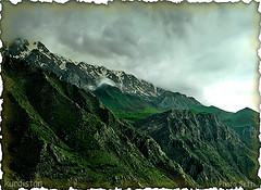
The most visible geophysical feature of Kurdistan is the mountainous terrain. Basically consisting of the northern and central Zagros, the mountains play an important geographical and symbolic role for the Kurdish, even having a saying that “Kurds have no friends but the mountains”. They helped shaped the history, tradition and culture of the Kurdish people. The Kurdish domains end where the plains begin. You will also find the only forest land at the highest mountain ridges. Due to the mountainous terrain, rain and snow flows down into the valleys feeding the rivers, which fulfills the agriculture needs of the region.
Kurdistan has an arid-continental climate, meaning the region has hot and dry summers, and cold and wet winters with an annual rainfall of 375-724 mm. Spring the most beautiful season, and a great time to travel, is when the Kurds celebrate Nawroz, their new year. The fall, also a great time to travel, is dry and mild.

